Drone mapping uses an unmanned aircraft to photograph your property from above, then turns those photos into maps, 3D models, and elevation data. Ground surveying sends a licensed professional onto your property to measure specific points, locate boundaries, and produce legal documents. Most serious land projects need both at different stages.
If you’ve ever needed a land survey, someone probably threw two options at you and expected you to just know the difference. Most people don’t. And picking the wrong one can cost you serious time and money before a single shovel hits the dirt.
So let’s sort this out plainly.
What Drone Mapping Actually Does
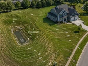
A drone survey sends an unmanned aircraft over your property. It takes hundreds of overlapping photos, and software stitches those together into detailed maps, 3D models, and elevation data.
It’s fast. A site that would take a ground crew two or three days to walk can be mapped by drone in a few hours. For large, open parcels like commercial lots, agricultural land, or construction sites with cleared ground, drone mapping is a strong choice. You get a massive amount of data quickly, and the cost per acre drops significantly compared to sending a full crew out.
Drone surveys work well for progress
photos, volume calculations for earthwork, and getting a bird’s-eye view of a site before design work starts. On open terrain, a drone with RTK positioning can hit vertical and horizontal accuracy within about one-tenth of a foot, which is solid data for most engineering decisions.
Fast doesn’t always mean right for your situation, though.
What Ground Surveying Does That a Drone Can’t
Ground surveying puts a licensed professional on your property with precision instruments. They measure specific points, locate property corners, check legal boundaries, and produce documents that hold up in court.
That last part matters more than most people realize.
A drone can give you a detailed 3D model of your land. What it can’t do on its own is establish legal property boundaries. That requires a licensed land surveyor to review historical records, verify boundary markers, and stamp a document that carries legal weight. No drone changes that.
Ground surveys also win on wooded or heavily vegetated properties. When a drone camera flies over a tree canopy, it maps the tops of the trees, not the ground underneath. So if you have a forested lot and someone does a basic photogrammetry drone survey, your elevation data reflects treetops, not soil. That’s a real problem for drainage design, grading plans, and construction layouts.
There is a fix. A drone equipped with LiDAR technology can fire laser pulses through gaps in tree cover and reach the actual ground. LiDAR can penetrate areas with up to 90% vegetation cover, while standard photogrammetry starts losing ground accuracy around 60%. But LiDAR equipment costs two to three times more per acre than photogrammetry, and that changes your budget conversation fast.
Where Things Get Confusing
People assume drone mapping and a certified land survey are the same thing. They aren’t.
A drone operator with an FAA Part 107 certificate can fly legally and produce impressive-looking maps. But producing a legal survey deliverable, one a title company, lender, or permit office will accept, requires a licensed land surveyor to be involved. In many states, offering survey-grade deliverables without that license is actually illegal.
Court cases have been filed over exactly this, including a recent case where the U.S. Supreme Court declined to hear a drone operator’s appeal after a state surveying board shut down his aerial mapping business entirely.
So when you call a company and ask for a “drone survey,” ask a follow-up question: is a licensed surveyor reviewing and certifying this data? If the answer is vague, pay attention to that.
Which One Fits Your Project?
Go with drone mapping when your site is mostly open, you need a fast topographic snapshot, you’re tracking construction progress, or you want volume calculations for earthwork. Research shows drone surveys can reduce project time by up to 45% and cut field costs by 50% compared to traditional ground-only methods. For large properties where walking every inch would take too long, the time savings alone justify it.
Stick with ground surveying, or a combination of both, when you need legal boundary work, you’re buying or selling property, you’re pulling permits that require certified data, or your site has heavy tree cover where standard drone cameras can’t see the ground.
For most mid-size development projects, the honest answer is both. Drone mapping handles the big picture fast. Ground surveying handles the precise legal work that aerial data alone can’t cover.
 What This Costs You If You Get It Wrong
Say you order a basic drone survey on a wooded lot. The data looks clean. Your engineer uses it for a grading plan.
Construction starts. Then someone realizes the elevation model was off because the drone mapped tree canopy, not ground. Fixing that mistake mid-project is expensive. Re-flying with LiDAR costs more than doing it right the first time. And if a permit reviewer rejects your data because no licensed surveyor certified it, you’re starting over.
Getting the right type of survey upfront is cheaper than correcting a bad one mid-build.
Still Not Sure? Start Here
Drone mapping is fast, affordable, and well-suited for open sites and large-scale data collection. Ground surveying is legally binding, precise, and required for boundary work, permits, and anything a title company will touch.
Most serious projects need both at some point. The real question is which one your project requires right now, and whether the person you hired knows the difference.
If you’re not sure, ask your surveyor to walk you through what the deliverable will be used for. A good one will tell you exactly what you need and why. A bad one will hand you a file and walk away.
Frequently Asked Questions
Can a drone survey replace a traditional land survey?
No. A drone survey can produce detailed maps and topographic data, but it can’t legally establish property boundaries. Only a licensed land surveyor can certify boundary data for legal, title, or permit purposes.
How accurate is a drone survey?
On open terrain with RTK positioning, a professional drone survey can achieve accuracy within 1 to 3 centimeters horizontally. Accuracy drops on vegetated sites unless LiDAR is used.
Do I need a licensed surveyor for drone work?
In most U.S. states, yes, if the deliverable will be used for legal, permitting, or engineering purposes. Flying a drone doesn’t require a surveyor’s license, but certifying the data does.
When should I use LiDAR instead of photogrammetry?
Use LiDAR when your site has dense tree cover or heavy vegetation and you need accurate ground elevation data beneath the canopy. For open sites, photogrammetry is faster and more cost-effective.