↓
 

Columbus Land Surveying

...providing land surveying services to the Greater Columbus, OH area.

Columbus Land Surveying Header
Columbus Land Surveying
  • Home
  • ALTA Survey
  • Boundary Surveying
  • Drone LiDAR Mapping
  • Elevation Certificate
  • Land Surveying
  • Topographic Survey
  • Blog
  • Contact Us
Home→topographic survey→How to Read a Topographic Survey Report →Topographic survey report property drainage overview

Image navigation

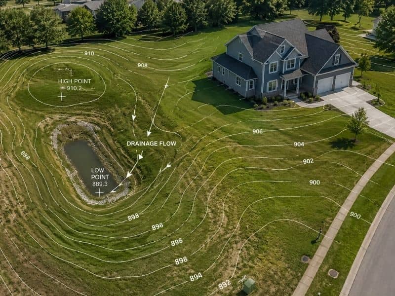
Topographic survey report property drainage overview

Published May 12, 2026 at 800 × 600 in How to Read a Topographic Survey Report
Aerial view of a residential property with contour lines showing elevation changes and drainage flow across the land

Image navigation

Get Quote Button

Recent Posts

  • How to Read a Topographic Survey Report
  • ALTA Survey Guide for Commercial Real Estate
  • How Elevation Certificates Affect Flood Insurance
  • What a Topographic Survey Shows
  • Why LiDAR Mapping Accuracy Alone Is Not Enough

Categories

  • alta survey
  • boundary survey
  • building survey
  • drone lidar mapping
  • elevation certificate
  • land surveying
  • land surveyor
  • topographic survey
© Copyright Columbus Land Surveying
250 W. Old Wilson Bridge Road, Suite 250
Worthington, Ohio 43085
Terms of Use  |  Privacy Policy
Web Development and SEO by:
N2Biz.co
↑