
How to Read a Topographic Survey Report
 So your surveyor just handed you a topographic survey report. You see lines, numbers, and symbols all over the page. At first glance, it may look confusing.
You are not alone. Most property owners feel the same way when they see a topographic survey for the first time. The good news is that once you learn the basics, the report becomes much easier to understand. Knowing how to read it can also help you avoid drainage problems, permit delays, and costly construction mistakes.
Whether you are building an addition, planning a new home, fixing drainage issues, or improving your property, understanding your survey is important.
Why Property Owners Need Topographic Surveys
Property owners often need a topographic survey before starting construction, additions, grading, or drainage improvements. The report helps show elevation changes, water flow, utility locations, and site conditions that may affect permits and construction plans.
Columbus continues to grow quickly. New homes, additions, and redevelopment projects are happening across the city. Because of this growth, accurate site information matters more than ever.
The City of Columbus also has stormwater rules for many construction projects. These rules help control flooding and drainage problems. A topographic survey helps show how water moves across the property before and after construction.
Without accurate topo data, projects may face:
- Permit delays
- Drainage issues
- Utility conflicts
- Extra grading costs
- Foundation problems
- Flooding concerns
The 5 Most Important Parts of a Topographic Survey Report
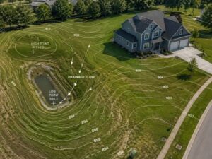
Contour Lines
Contour lines on a topographic survey connect points of equal elevation and show the slope and shape of the land. Lines close together show steeper ground, while lines farther apart show flatter areas.
Contour lines are usually the curved lines you see across the map. These lines show how the ground rises and falls.
Here is the easiest way to understand them:
- Lines close together = steeper slope
- Lines far apart = flatter land
Even though much of Columbus looks flat, many properties still have small elevation changes that affect drainage.
Water may flow:
- Toward your home
- Into a low spot in the yard
- Toward a neighbor’s property
- Into a drainage ditch or basin
Understanding contour lines can help you spot drainage problems before construction starts.
Contour Interval
The contour interval shows how much elevation changes between contour lines on a topographic survey. Smaller intervals provide more detail and are often used for drainage and grading projects.
Your survey may include a note such as:
- Contour Interval = 1 Foot
- Contour Interval = 2 Feet
This tells you how much the elevation changes between each contour line.
A one-foot interval gives more detail and is common for:
- Residential grading
- Drainage design
- Permit applications
- Site planning
A two-foot interval shows less detail and may not work well for some projects.
If your property has drainage or flooding concerns, ask your surveyor if the contour interval is right for your project.
Benchmark Elevations and Datum
Benchmark elevations show how high different points on the property sit above sea level. Surveyors use a standard system called NAVD 88 to keep measurements accurate and consistent.
Throughout the survey, you may see numbers such as:
- 893.4
- 901.7
- 905.2
These numbers show elevation points across the property.
Elevation matters because even small changes in height can affect:
- Drainage flow
- Flood risk
- Foundation design
- Retaining walls
- Flood insurance costs
According to FEMA flood maps, even a small elevation difference may affect whether a property falls inside a flood zone.
If your survey does not list the datum used, ask your surveyor. Elevation numbers are not useful without it.
Existing Features and Utility Symbols
Topographic survey reports also include symbols for features already on the property. These symbols help property owners and contractors understand what is on the site before construction begins.
Your survey may show:
- Trees
- Fences
- Sidewalks
- Driveways
- Utility poles
- Water lines
- Sewer lines
- Storm drains
- Catch basins
- Existing structures
Pay close attention to underground utilities.
According to Common Ground Alliance reports, underground utility strikes happen thousands of times each year because of missing or outdated site information. Damaging buried lines can create safety problems and expensive repairs.
In Columbus, utility conflicts are one of the most common causes of project delays.
Property Lines vs. Topographic Data
A topographic survey shows land elevations and site features, while a boundary survey legally identifies property lines. A topo survey should not be used to settle property disputes without a separate boundary survey.
This is one of the most common misunderstandings among property owners.
Many people think a topo survey legally confirms property lines. In most cases, it does not.
If you need to:
- Build a fence
- Solve a property dispute
- Confirm boundary locations
- Build close to a property line
- Handle an encroachment issue
you will likely need a separate boundary survey.
A topographic survey and a boundary survey serve different purposes, even when both appear on the same plans.
Red Flags to Watch for in Your Survey Report
Before using your topographic survey for permits or construction, check for missing information or signs that the report may be outdated or incomplete.
Watch for these warning signs:
- No datum listed
- Missing utility information
- Old survey date
- Missing surveyor seal
- Poor drainage details
- Contour interval too large for the project
- Missing easements or drainage structures
In Ohio, surveys used for permits or legal purposes should be signed and sealed by a licensed professional surveyor.
If something looks unclear, ask questions before construction begins. Fixing problems early is usually much cheaper than fixing them later.
Understanding Your Survey Can Save You Time and Money
Reading a topographic survey report may seem difficult at first, but learning the basics can help you make smarter decisions about your property.
A clear and accurate survey can help prevent:
- Drainage problems
- Permit delays
- Construction mistakes
- Utility conflicts
- Flooding concerns
- Costly redesigns
If you are planning a project, getting accurate survey information early can save you time, money, and stress later on.
Frequently Asked Questions
How long is a topographic survey valid?
Many surveyors recommend updating a topographic survey if it is more than one year old or if site conditions have changed.
Does a topographic survey show property lines?
A topographic survey may show approximate property lines for reference, but it is not the same as a legal boundary survey.
Can a topographic survey show drainage problems?
Yes. Contour lines and elevation points help show how water moves across the property.
Do I need a topographic survey for a home addition?
In many cases, yes. Columbus may require one for additions, grading work, drainage changes, and new structures.
What is the difference between a topographic survey and an ALTA survey?
A topographic survey focuses on land elevation and site features, while an ALTA survey is a detailed commercial property survey used for real estate and development projects.