↓
 

Columbus Land Surveying

...providing land surveying services to the Greater Columbus, OH area.

Columbus Land Surveying
  • Home
  • ALTA Survey
  • Boundary Surveying
  • Drone LiDAR Mapping
  • Elevation Certificate
  • Land Surveying
  • Lot Survey
  • Topographic Survey
  • Contact Us
Home 1 2 3 4 5 >>

Post navigation

← Older posts

Welcome to Columbus Land Surveying

Columbus Land Surveying Posted on August 9, 2017 by ColumbusSurveyorFebruary 12, 2020

Welcome to Columbus Land Surveying’s website

This site is intended to provide you with information on Land Surveying in the Columbus, OH, Franklin County, OH and the surrounding areas.  If you’re looking for a Columbus Land Surveyor, you’ve come to the right site. If you’d rather talk to someone about your land surveying needs, please call (614) 591-8665 today. For more information, please continue to read.

montgomery land surveying

Land Surveyors are professionals who measure and make precise measurements to determine the size and boundaries of a piece of real estate.  While this is a simplistic definition, boundary surveying is one of the most common types of surveying related to home and land owners. If you fall into the following categories, please click on the appropriate link for more information on that subject:

Columbus Land Surveying services:

  1. I need to know where my property corners or property lines are. (Boundary Survey)
  2. I have a loan closing or re-finance coming up on my home in a subdivision. (Lot Survey)
  3. I need a map of my property with contour lines to show elevation differences for my architect or engineer. (Topo Survey)
  4. I’ve just been told I’m in a flood zone or I ‘ve been told I need an elevation certificate in order to obtain flood insurance or prove I don’t need it. (Flood Survey)
  5. I’m purchasing a lot/house in a recorded subdivision. (Lot Survey – See Boundary Survey)
  6. I’m purchasing a larger tract of land, acreage, that hasn’t been subdivided in the past. (Boundary Survey)

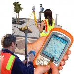
If your needs don’t fall into one of the above, don’t worry, we’ll get to the bottom of it. CALL Columbus Land Surveying TODAY at (614) 591-8665 OR better yet, fill out a Contact Form request to discuss your survey needs.

Posted in boundary survey, elevation certificate, land surveying, land surveyor | Tagged boundary survey, FEMA, flood map, Land Surveying, land surveyor

How To Find Your Home On FEMA’s Flood Insurance Rate Maps

Columbus Land Surveying Posted on December 24, 2017 by ColumbusSurveyorFebruary 11, 2020

What is are FEMA flood maps?

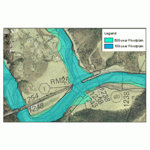
flood mapsFEMA’s Flood Insurance Rate Maps (FIRMs) or just Flood Maps are provided after a flood risk assessment has been completed or updated for a community.  This study is known as a Flood Insurance Study.  The FIRM gives you the Base Flood Elevations (BFEs) and insurance risk zones in addition to floodplain boundaries.  The FIRM may also show a delineation of the regulatory floodway. 

Once the “insurance risk zone”  (commonly referred to as the flood zone) is determined, actuarial rates, based on these risk zones, are then applied for newly constructed, substantially approved, and substantially damaged buildings.  FEMA uses these rates to determine the insurance rate you will pay for flood insurance

FEMA’s Digital Flood Maps

FEMA discontinued the production and distribution of paper flood maps in 2009 as part of its Digital Vision Initiative. This affected all the Flood Maps, boundary information, and study reports. However, clients can still view the products for free through their website or buy them in digital format.

To view these flood maps online, go to FEMA’s Map Service Center and key in your address (hi-lited area shown here) search for your home.  This will prompt you to then select the map that covers your area.  The Flood Maps are somewhat cumbersome to use online. It is best to go through the tutorial on the bottom right of the address search page for an easier and more effective use of the GIS map.

Columbus Flood Maps by FEMA

If you are located in the City of Columbus, you might also want to check the Columbus Interactive GIS maps for more information and a little easier interface. Check the FEMA Flood Insurance Rate Map box on the left to view the flood zones on this map.

Call Columbus Land Surveying at  (614) 591-8665 or  contact us if you need help with this process or if you discover you are near a flood zone and need an elevation survey completed.  We are here to help you minimize your flooding risk.

Posted in elevation certificate | Tagged FEMA, flood, flood map, flood zone, National Flood Insurance Program, NFIP

Land Surveyor: Famous Land Disputes All Over the World

Columbus Land Surveying Posted on October 12, 2017 by ColumbusSurveyorFebruary 11, 2020
land surveyor

land surveyorA land surveyor may not be recognized as much as a doctor or a lawyer, but no one can dispute that they play a very crucial role on Earth. As proof, several countries all over the world have unsettled land disputes over other countries. Some may have been settled through the International Court of Justice, Treaty conditions, or a claimant country’s sovereignty has been recognized. And of course, these were all settled with the help of a land surveyor.

Let’s take a look at some of the famous land disputes all over the world settle by a land surveyor:

  • Mayotte (Africa) – Claimants are France and Comoros. France gained full control under the 2009 referendum, the population supported becoming an overseas department of France, and so became one on March 31, 2011.
  • Ligitan and Sipadan (Asia) – Claimants are Malaysia and Indonesia. The 2002 International Court of Justice ruling awarded both islands to Malaysia, but left unsettled the maritime boundary immediately southwest and west of the islands between Malaysia and Indonesia.
  • Eastern coast of Narva and Petseri County (Europe) – Claimants are Russia and Estonia.Russia recognized them as a part of Estonia with Treaty of Tartu, 1920. After the fall of the Soviet Union, Russia continued administering it.
  • Tuzla Island and Strait of Kerch; Sarych (Europe) – Claimants are Ukraine and Russia. The conflict arose in 2003 when the Russian authorities started to build a dam towards the island. Since then Ukraine established a border garrison on the island for a closer surveillance. The reason for the conflict is the fact that Tuzla island strategic location gives Ukraine full rights over the main channel in the Strait of Kerch and, thus, the access to the Sea of Azov.
  • San Andrés and Providencia (Central America/Caribbean) – Claimants are Colombia and Nicaragua. Colombia currently has full control because Honduras de facto recognises Colombian claim.
  • Los Monjes Archipelago (South America) – Claimants are Venezuela and Colombia. Velenzuela gains full control because Colombia no longer claims the islands, only the surrounding waters.

A piece of parcel is something that signifies power and resources thus many countries fight over it. If big countries have unsettled disputes over a piece of land, small land disputes also happen between siblings, husband and wife, and neighbors. Though you can’t hire a land surveyor from an International Court to settle your small land disputes, you can always hire a local land surveyor who can survey your property and resolve any encroachment claims and/or equally divide a property as mandated by law.

A land surveyor plays a very vital role in settling land disputes, big or small. If you are in a situation that you may need the expertise of a land surveyor, please contact Columbus Land Surveying at (614) 591-8665 today or go to our Contact page and send us an email.

Posted in land surveying, land surveyor | Tagged columbus land surveying, famous land disputes, land disputes, Land Surveying, land surveying columbus, land surveyor, land surveyor columbus

Post navigation

← Older posts
Get Quote Button

Recent Posts

  • How To Find Your Home On FEMA’s Flood Insurance Rate Maps
  • Land Surveyor: Famous Land Disputes All Over the World
  • Welcome to Columbus Land Surveying
  • What is a Topo Surveyor?
  • Flooding From Excessive Rain Downstream From Earth Dams

Categories

  • boundary survey
  • building survey
  • elevation certificate
  • land surveying
  • land surveyor
  • topographic survey
© Copyright Columbus Land Surveying
250 W. Old Wilson Bridge Road, Suite 250
Worthington, Ohio 43085
Terms of Use  |  Privacy Policy
Web Development and SEO by:
N2Biz.co
↑