 When you look at homes or land in areas marked as flood zones, you cannot rely only on basic maps or neighborhood stories. An elevation certificate gives you clear facts about how high the building sits above known flood levels. This document is more than just a formality, it is the best way to understand what you are actually buying before you commit. Starting here keeps you from facing unexpected costs or risks later in the process.
Many buyers skip this step because they assume all properties in the same zone carry the same risk. In reality, the details found in an elevation certificate change how you view the property and its long-term value.
An Elevation Certificate Can Answer Questions Before You Make an Offer
Before you put any money down or sign a contract, you need real information to guide your choice. Flood maps show general areas, but they do not tell you exactly how high the foundation or main floor of a house sits. An elevation certificate measures these exact heights and compares them to the level where flooding is expected.
With this information, you can ask better questions about safety, future maintenance, and possible costs. You will know if the home sits well above risk levels or if it sits close to the line where problems could start. Having these answers early lets you decide if the property fits your budget and comfort level before negotiations begin.
Comparing Two Flood Zone Properties Isn’t Always an Apples to Apples Decision
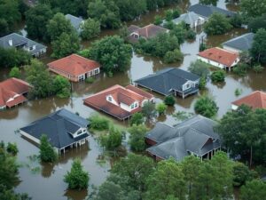
You might find two homes right next to each other, both listed in the same flood zone. It is easy to think they face the same conditions, but that is often not true. One house may have its main floor built two feet higher than the other, even though they share the same street. Small differences in height create big differences in how much risk the home faces.
Other details also play a part. The age of the structure, how it was built, and changes made to the land around it can shift the level of protection. An elevation certificate shows these differences clearly. You can use flood zone elevation details to see exactly how each property stands and avoid treating them as identical just because they fall inside the same boundary line.
Using Elevation Certificate Information During Property Due Diligence
Checking a property means looking at many different parts of the deal. You review the title, arrange for a home inspection, and confirm the price matches similar sales. Adding an elevation certificate to this list gives you another key piece of the puzzle. It works alongside these other checks to build a full picture of what you are purchasing.
This document helps you spot conditions that maps alone cannot show. It supports conversations with lenders, who use it to understand risk, and with contractors, who can explain what changes might be needed. It does not replace any other step, but it fills in gaps that other reports leave open. You can rely on property elevation records to make sure no important detail stays hidden.
Questions Buyers Should Ask Before Purchasing Property in a Flood Zone
Once you have the certificate in hand, you can move from guessing to asking specific, useful questions. These questions help you learn more about the property and plan for what comes next. You can ask:
- How does the building’s height compare to the required safe level?
- Have there been any changes to the foundation or ground level since the last measurement?
- Does the document match the current flood zone rules for this area?
- If changes are needed, what kind of work would be required and what would it cost?
- How long ago was the certificate prepared, and does it still reflect the property as it stands today?
These questions turn raw numbers into useful knowledge. They help you talk openly with sellers, agents, and experts so you understand exactly what you are getting into.
Making a Confident Purchase Without Relying on Assumptions
Most mistakes in buying happen when people assume things are true without proof. You might hear that a neighborhood never floods, or that older homes are built to handle water. These ideas can be wrong, and they can lead to expensive surprises. An elevation certificate replaces guesswork with facts.
When you base your decision on measured data, you know exactly what risk you are taking. You can decide if the property fits your plans, and you can enter the deal with clear eyes. This approach removes uncertainty and gives you confidence that your choice is based on real conditions, not stories or general rules.
Frequently Asked Questions
Should I request an Elevation Certificate before making an offer on a flood-zone property?
Yes. Having it early lets you understand risk and cost before you commit. It helps you decide if the property is worth pursuing and gives you facts to use during negotiations.
Can an Elevation Certificate help buyers compare multiple properties in the same flood zone?
Absolutely. It shows the exact height of each building. This lets you see which one sits higher and safer, even if both are listed in the same general area.
Does an Elevation Certificate replace a home inspection during the buying process?
No. It focuses only on elevation and flood-related details. It works alongside inspections, appraisals, and title reviews to give you a complete view of the property.
Who should provide the Elevation Certificate during a real estate transaction?
Usually the seller provides it if one already exists. If there is no current document, you can arrange for a licensed surveyor to prepare one before closing.
Can an outdated Elevation Certificate affect a property purchase decision?
Yes. If the document is old or does not match recent changes to the home or land, it may not reflect current conditions. Using old information can lead to wrong assumptions about risk.
What other documents should buyers review alongside an Elevation Certificate before closing?
You should look at flood zone maps, home inspection reports, title documents, and insurance quotes. Together, these items give you a full understanding of the property’s value and risk.