
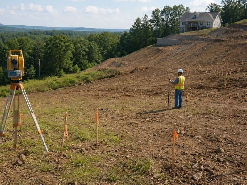
What a Topographic Survey Shows
You finally found a sloped lot that feels right, and now a topographic survey may become one of the most important parts of planning your future build.
The view looks great. The trees add privacy. The yard seems large enough for the home you want to build. At first glance, the slope may not even look like a problem.
Then construction planning begins.
Suddenly, the builder starts talking about drainage, grading, runoff, retaining walls, and driveway angles. What looked like a simple piece of land now feels more complicated.
That is why a topographic survey matters before building on a sloped lot.
It helps show how the land actually works before you spend money on plans, permits, or construction.
Why Sloped Lots Create Construction Problems
A sloped lot can affect drainage, grading, driveway placement, and foundation stability before construction begins. Even small elevation changes may create water runoff problems or increase site preparation costs. A topographic survey helps builders understand how the land behaves before designing the project.
Many people think a slope only affects how the yard looks. However, the shape of the land affects almost every part of construction.
Water moves downhill. Soil shifts over time. Driveways need safe angles. Foundations need stable ground.
Even a small slope can create problems if nobody studies the property early.
This happens often around Columbus. Some lots look flat from the road, yet the back portion may drop several feet. In other cases, the land may tilt enough to push rainwater toward the future home.
Columbus also receives around 40 inches of rain each year. Because of that, poor drainage on sloped land can become a serious issue during heavy storms.
Without clear elevation data, builders end up guessing.
That guesswork can become expensive later.
What Does a Topographic Survey Show?
A topographic survey shows elevation changes, slopes, drainage paths, low areas, and visible surface features across a property. Builders and engineers use this information to plan grading, drainage, foundations, driveways, and other improvements before construction starts on sloped land.
A topographic survey maps the shape of the land.
Instead of only showing property lines, it shows elevation changes across the site. Surveyors collect points throughout the lot and connect them to create a detailed picture of the ground.
A topographic survey commonly identifies:
- high points across the lot
- low areas where water collects
- steep slopes
- drainage flow paths
- hills and embankments
- visible surface features
- elevation changes near the future home site
These details help builders understand what they are working with before construction starts.
For example, a lot may appear level when standing on it. However, the survey may reveal a steady slope toward the future foundation area. That small detail can affect drainage design, grading costs, and foundation planning.
Modern surveying equipment also provides highly accurate elevation measurements. As a result, engineers can create better grading and stormwater plans before construction begins.
Why Drainage Problems Often Start Before Construction
Drainage problems often begin when rainwater flows toward the future home site instead of away from it. A topographic survey helps identify low areas and natural runoff patterns early so builders can design proper grading and drainage systems before construction begins.
Most issues on sloped lots start with water.
Rainwater always follows the lowest path. If the property slopes toward the home site, water may collect near the foundation after storms.
That can lead to:
- standing water
- muddy yards
- erosion
- foundation moisture problems
- drainage repairs later
Sloped lots also face a higher risk of erosion because water moves faster downhill during heavy rain.
A topographic survey helps engineers and builders see these risks early.
As a result, they can design proper drainage systems before construction begins. They may adjust grading plans, move the home location slightly, or add drainage features that protect the property long term.
Fixing drainage problems after construction often costs far more than identifying them during site planning.
How Topographic Surveys Help With Driveway and Grading Design
A topographic survey helps measure slope angles and elevation changes before driveway and grading plans are finalized. Accurate elevation data helps reduce drainage problems, unsafe driveway slopes, erosion, and expensive layout changes during construction on sloped lots.
Driveways on sloped lots need careful planning too.
If the driveway becomes too steep, it may create problems during rain, snow, or ice. Vehicles can struggle to enter safely, especially during Ohio winters.
At the same time, poor driveway grading can send water toward the garage or foundation.
A topographic survey helps builders measure the slope correctly before finalizing the layout.
That way, the driveway works better and drains properly.
This step may sound small, yet it often prevents expensive changes later.
When Retaining Walls Become Necessary
Some sloped lots need retaining walls to create flat building areas.
These walls help hold soil in place and reduce erosion. However, retaining walls add cost and require proper engineering.
A topographic survey helps show where elevation changes become too steep for normal grading alone.
In some cases, larger retaining walls may also require engineering review or permits before construction begins.
Without this information, property owners sometimes discover the need for retaining walls after construction plans are already finished.
At that point, redesigns can delay the project and increase costs.
Early survey data helps avoid those surprises.
Why Flat-Looking Lots Can Still Have Elevation Problems
One of the biggest mistakes people make is trusting what their eyes see from ground level.
A property can look mostly flat while still having important elevation changes.
Small dips and gradual slopes are hard to notice without accurate measurements. Yet those changes still affect water flow and construction planning.
This becomes even more important in neighborhoods around Columbus where older lots may have uneven grading from past development.
Some lots also contain hidden drainage paths that only become obvious during heavy rain.
A topographic survey gives a clearer picture before those issues turn into construction delays.
When Should You Order a Topographic Survey?
The best time to order a topographic survey is before designing or building on the property. Early elevation data helps property owners understand drainage, grading needs, and slope conditions before construction plans, permits, and excavation work begin.
Many people wait until problems appear. However, early survey information gives you more options and better control over the project.
A topographic survey makes sense before:
- buying vacant land
- building a custom home
- adding large outdoor features
- planning major grading work
- designing a driveway on a hill
- expanding a home on uneven land
The earlier you understand the property, the easier planning becomes.
Why a Topographic Survey Helps Reduce Construction Surprises
Sloped lots can create beautiful home sites. They often offer better views, more privacy, and unique layouts.
Still, those same lots can create drainage, grading, and foundation challenges if nobody studies the land carefully.
A topographic survey helps remove the guesswork.
It shows how the property actually behaves before construction begins. That information helps builders design smarter, avoid delays, and reduce costly surprises later.
Before building on a sloped lot, understanding the shape of the land may become one of the most important steps in the entire project.
Frequently Asked Questions
Do I need a topographic survey before building?
Many builders recommend a topographic survey before designing or building on sloped land because it helps identify elevation changes, drainage issues, and grading needs early.
Can a topographic survey help with drainage problems?
Yes. A topographic survey helps show how water moves across the property so engineers and builders can design better drainage systems before construction begins.
Does a topographic survey show elevation?
Yes. One of the main purposes of a topographic survey is to measure elevation changes across the property and identify slopes, low areas, and drainage paths.
What problems can a sloped lot cause?
Sloped lots can create drainage issues, erosion, steep driveway problems, retaining wall needs, and foundation concerns if the land is not properly evaluated before construction.
When should I order a topographic survey?
The best time is before design work starts so builders and engineers can plan around the existing slope and drainage conditions.