
Construction Staking for Detention Basin Installation
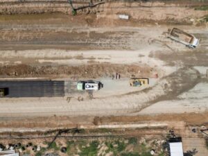
A detention basin that ends up six inches too shallow can lose thousands of gallons of storage. That missing volume often stays hidden until the first heavy storm, when water backs up into a parking lot or spills toward a neighboring property. Construction staking keeps that from happening. It turns the engineer’s basin design into marks on the ground that show the crew where to dig, how deep to go, and where each pipe belongs.
This guide is for contractors, site developers, and project managers getting ready to build a stormwater detention basin. You’ll see how survey data shapes the layout, what gets staked, and how grades are checked during and after excavation. The main lesson is to bring your surveyor in before the first bucket of dirt moves and keep them involved until the basin is verified.
How Survey Data Guides Detention Basin Layout
Construction staking for a detention basin starts with existing survey data. Most sites get a topographic survey first, which maps ground elevations, drainage paths, utilities, and property lines. The civil engineer uses that data to size the basin and decide where it sits. If the topo is outdated or thin, the layout can be off before a single stake goes in.
The surveyor then sets a control network on the site. Control points are fixed positions with known coordinates and elevations, and every later stake is measured from them. Good control is why a stake set on Monday lines up with one set weeks later by a different crew.
These early checks are easy to skip on a fast schedule. They also prevent more rework than almost anything else. Before staking starts, confirm with your surveyor that:
- The plans and CAD files are the latest approved version
- The benchmark elevation in the field matches the one on the plans
- Changes from plan review have been carried into the staking files
Staking Basin Limits and Key Elevations
The first stakes usually mark the outer limits of the basin. These include the top of bank, the toe of slope, and any limits of disturbance shown on the plans. Top of bank is the upper edge where the side slope meets surrounding ground. Toe of slope is the lower edge where that slope reaches the basin floor.
Each stake carries more than a location. Surveyors mark the point number, the offset from the design line, and the cut or fill needed. A “C-3.5” mark tells the operator to cut 3.5 feet below the ground at that spot. Offset stakes are often set a few feet outside the work zone so they survive equipment traffic.
Key elevations need extra care. These include the basin bottom, top of berm, emergency spillway crest, and the outlet discharge levels. The spacing between these elevations controls how much water the basin can hold.
Setting Grades for Excavation and Slopes
Grade stakes guide the crew as the basin takes shape. Side slopes are often designed at ratios like 3 to 1 or 4 to 1, meaning the bank rises one foot for every three or four feet across. Steeper slopes can erode or become hard to mow, while flatter ones use more land. The engineer picks a ratio for a reason, so the field slope should match it.
Slope stakes mark the catch point, where the design slope meets existing ground. Natural ground is rarely flat, so that point shifts around the basin and has to be calculated at each station. Many contractors run machine control on dozers and excavators. Even then, a surveyor sets the site control and often builds or checks the surface model the machine follows.
Basin floors usually slope gently toward the outlet so water drains fully. A floor meant to fall half a percent can end up flat or tilted the wrong way without grade checks. Ask for checks during excavation, while the equipment is still on site and fixes are cheap.
Locating Inlets, Outlets, and Drainage Structures
Pipes and structures are where a few inches matter most. The surveyor stakes the location and invert of each inlet pipe, outlet pipe, and outlet control structure. An invert is the lowest inside point of a pipe, where water runs along the bottom. An outlet set too high can hold water longer than the design intended, and an inlet set too low may silt up.
Outlet control structures often have orifices, weirs, or risers at exact heights. These openings meter how fast water leaves during different storm sizes. Staking typically covers the structure’s center point, orientation, and the elevation of each opening. Headwalls, rip rap aprons, and the emergency spillway are often staked at this stage too.
Verifying Basin Construction Against Design Plans
Once grading and structures are done, the basin should be checked against the approved design. The surveyor collects shots across the floor, slopes, berm, spillway, and structures. Those points are compared to design elevations to confirm storage volume. Some reviewing agencies require this data in an as-built or record drawing, though requirements vary by municipality, county, and project.
If something is off, the data shows exactly where. The engineer of record then decides whether the difference is acceptable or needs correction. Some projects can’t close permits or release bonds until storage is confirmed, so ask your reviewing office early what documentation they expect.
Frequently Asked Questions
What is construction staking for a detention basin?
Construction staking for a detention basin is the process of marking the basin’s design on the ground. A surveyor sets stakes that show the basin limits, slopes, floor grades, and structure locations. Each stake tells the crew where to dig and how much to cut or fill. This keeps the finished basin close to what the engineer designed.
When should a surveyor be brought into the project?
Bring the surveyor in before excavation starts, ideally while plans are being finalized. Early involvement lets them confirm control points, benchmarks, and the latest design files. It also leaves time to stake limits of disturbance and erosion control lines before grading. Waiting until the crew is ready to dig often causes delays.
Do I still need staking if my contractor uses machine control?
Most projects still need survey work even with machine control. A surveyor sets site control and often builds or checks the surface model the equipment follows. Pipes, structures, and spillways are usually staked by hand for accuracy. Spot checks during grading also catch errors a machine model can miss.
How accurate does detention basin staking need to be?
Required accuracy depends on project specs, the engineer’s tolerances, and the reviewing agency. Pipe inverts and outlet openings usually need the tightest control because small errors change how the basin drains. Slopes and berms may allow a little more room, but they still affect storage. Your project specifications should list the tolerances that apply.
What happens if the finished basin doesn’t match the plans?
The surveyor’s verification data shows where the basin differs from the design. The engineer of record then reviews whether the difference affects storage or discharge. Minor differences may be accepted, while larger ones can require regrading or structure changes. Finding these issues before final inspection costs far less than fixing them later.